
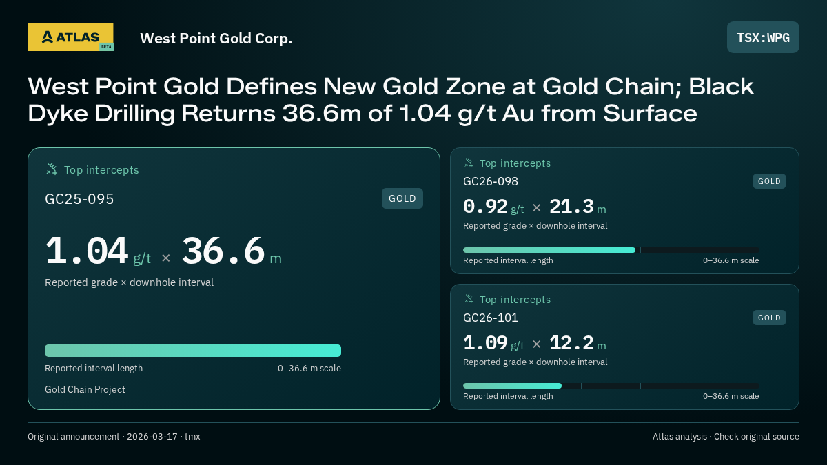
West Point Gold Defines New Gold Zone at Gold Chain; Black Dyke Drilling Returns 36.6m of 1.04 g/t Au from Surface
Original announcement by tmx on
- Company
- West Point Gold Corp.
- Ticker
- WPG
- Exchange
- TSX
- Region
- Arizona
- Primary commodity
- Gold
- Secondary commodities
- Silver
- Document categories
- Drill results, Other
- Extracted
- 2026-08-22 18:48:38 UTC
Analysis by Minestarters Atlas
Minestarters Atlas analysis
Summary
West Point Gold has identified a new shallow gold-bearing zone at the Black Dyke target within its Gold Chain Project in Arizona. Initial RC drilling confirmed mineralization from surface, with the zone remaining open along strike and down-dip.
Reasoning: The announcement defines a new prospective area (Black Dyke) at the Gold Chain project with shallow, continuous mineralization, representing a meaningful milestone for resource expansion.
Positive factors
- discovery of new gold zone
- shallow mineralization from surface
- zone open in multiple directions
- structural intersection potential
Negative factors
- grades are moderate compared to project average
Facts used in scoring: 5
Classification and evidence
Step-Out Extensionpositive
Mineralization extended beyond the previously known limit.
Why it applies: The Black Dyke target is described as a new area 4km west of the Tyro Main Zone, representing a new discovery/extension of the project footprint.
Evidence · text
“Black Dyke target located four kilometres ("km") west of the Tyro Main Zone”
QA/QC Disclosedpositive
Release includes QA/QC disclosure — certified lab, QP sign-off, or stated methods (blanks, standards, duplicates).
Why it applies: The release details the use of certified standards, blanks, and duplicates, and names the laboratory.
Evidence · text
“Both certified standards and blanks were inserted on site along with duplicates”
Extracted facts
Stored fact records: 5. Some facts used in scoring do not have a stored record.
Drill Results (5)
GC25-095Gold Chain Project · goldGrade: 1.04Grade Unit: g/tIntercept: 36.6 mView all detailsHide details
Identity
- Hole ID
- GC25-095
- Project
- Gold Chain Project
- Commodity
- gold
- Region
- usa_az
- Reported Region
- Arizona
- Ticker
- WPG
Geometry
- Grade
- 1.04
- Grade Unit
- g/t
- Intercept
- 36.6 m
- From
- 0 m
- To
- 36.6 m
Classification
- Program
- exploration
- Sample Type
- drill
- Group ID
- GC25-095:0-36.6
- Mining Method
- open_pit
QA/QC
- Laboratory
- American Assay Laboratories
- QA/QC Disclosed
- Yes
- Lab Certified
- Yes
- QP Signed
- Yes
- QA/QC Methods
- blanks, standards, duplicates
Review
- Needs Review
- No
- Interp. Status
- scored
- Historical
- No
Dates
- Event date
- 2026-03-17T00:00:00.000Z
Reasoning: 36.6m intercept from surface confirms the presence of the new Black Dyke zone.
Positive factors
- significant width
- from surface
Negative factors
- grade is below project average
Evidence · table
“1.04”
Context: 36.6
GC25-097Gold Chain Project · goldGrade: 0.8Grade Unit: g/tIntercept: 10.6 mView all detailsHide details
Identity
- Hole ID
- GC25-097
- Project
- Gold Chain Project
- Commodity
- gold
- Region
- usa_az
- Reported Region
- Arizona
- Ticker
- WPG
Geometry
- Grade
- 0.8
- Grade Unit
- g/t
- Intercept
- 10.6 m
- From
- 4.6 m
- To
- 15.2 m
Classification
- Program
- exploration
- Sample Type
- drill
- Group ID
- GC25-097:4.6-15.2
- Mining Method
- open_pit
QA/QC
- Laboratory
- American Assay Laboratories
- QA/QC Disclosed
- Yes
- Lab Certified
- Yes
- QP Signed
- Yes
- QA/QC Methods
- blanks, standards, duplicates
Review
- Needs Review
- No
- Interp. Status
- scored
- Historical
- No
Dates
- Event date
- 2026-03-17T00:00:00.000Z
Reasoning: Moderate width intercept confirming mineralization.
Negative factors
- low grade
Evidence · table
“0.80”
Context: 10.6
GC26-098Gold Chain Project · goldGrade: 0.92Grade Unit: g/tIntercept: 21.3 mView all detailsHide details
Identity
- Hole ID
- GC26-098
- Project
- Gold Chain Project
- Commodity
- gold
- Region
- usa_az
- Reported Region
- Arizona
- Ticker
- WPG
Geometry
- Grade
- 0.92
- Grade Unit
- g/t
- Intercept
- 21.3 m
- From
- 21.3 m
- To
- 42.7 m
Classification
- Program
- exploration
- Sample Type
- drill
- Group ID
- GC26-098:21.3-42.7
- Mining Method
- open_pit
QA/QC
- Laboratory
- American Assay Laboratories
- QA/QC Disclosed
- Yes
- Lab Certified
- Yes
- QP Signed
- Yes
- QA/QC Methods
- blanks, standards, duplicates
Review
- Needs Review
- No
- Interp. Status
- scored
- Historical
- No
Dates
- Event date
- 2026-03-17T00:00:00.000Z
Reasoning: 21.3m width supports the continuity of the Black Dyke zone.
Positive factors
- good width
Negative factors
- low grade
Evidence · table
“0.92”
Context: 21.3
GC26-099Gold Chain Project · goldGrade: 1.56Grade Unit: g/tIntercept: 7.6 mView all detailsHide details
Identity
- Hole ID
- GC26-099
- Project
- Gold Chain Project
- Commodity
- gold
- Region
- usa_az
- Reported Region
- Arizona
- Ticker
- WPG
Geometry
- Grade
- 1.56
- Grade Unit
- g/t
- Intercept
- 7.6 m
- From
- 62.5 m
- To
- 70.1 m
Classification
- Program
- exploration
- Sample Type
- drill
- Group ID
- GC26-099:62.5-70.1
- Mining Method
- open_pit
QA/QC
- Laboratory
- American Assay Laboratories
- QA/QC Disclosed
- Yes
- Lab Certified
- Yes
- QP Signed
- Yes
- QA/QC Methods
- blanks, standards, duplicates
Review
- Needs Review
- No
- Interp. Status
- scored
- Historical
- No
Dates
- Event date
- 2026-03-17T00:00:00.000Z
Reasoning: Highest grade intercept in the reported set.
Positive factors
- highest grade in table
Negative factors
- narrow width
Evidence · table
“1.56”
Context: 7.6
GC26-101Gold Chain Project · goldGrade: 1.09Grade Unit: g/tIntercept: 12.2 mView all detailsHide details
Identity
- Hole ID
- GC26-101
- Project
- Gold Chain Project
- Commodity
- gold
- Region
- usa_az
- Reported Region
- Arizona
- Ticker
- WPG
Geometry
- Grade
- 1.09
- Grade Unit
- g/t
- Intercept
- 12.2 m
- From
- 114.3 m
- To
- 126.5 m
Classification
- Program
- exploration
- Sample Type
- drill
- Group ID
- GC26-101:114.3-126.5
- Mining Method
- open_pit
QA/QC
- Laboratory
- American Assay Laboratories
- QA/QC Disclosed
- Yes
- Lab Certified
- Yes
- QP Signed
- Yes
- QA/QC Methods
- blanks, standards, duplicates
Review
- Needs Review
- No
- Interp. Status
- scored
- Historical
- No
Dates
- Event date
- 2026-03-17T00:00:00.000Z
Reasoning: Confirms mineralization at depth.
Evidence · table
“1.09”
Context: 12.2
How Atlas produces this analysis
Minestarters Atlas uses automated extraction to summarize mining announcements, identify reported measurements, and classify supporting evidence. Sentiment reflects the extracted narrative and classification rules; it is an interpretation, not a reported measurement. Evidence quotes and context are provided where available. Missing data, low-confidence results, and review flags indicate limitations. Check the original publisher announcement before relying on an interpretation.