
Legacy Gold Advances Core Drilling to Undrilled Northwest Zone at the Baner Gold Mine Property; RC Drilling on Target for July Start
Original announcement by tmx on
- Company
- Legacy Gold Mines Ltd.
- Ticker
- LEGY
- Exchange
- TSX
- Region
- Idaho County, Idaho
- Primary commodity
- Gold
- Secondary commodities
- None reported
- Document categories
- Drill results, Other
- Extracted
- 2026-08-25 18:34:05 UTC
Analysis by Minestarters Atlas
Minestarters Atlas analysis
Summary
Legacy Gold is advancing core drilling to the previously undrilled Northwest Zone at the Baner Gold Mine Property in Idaho. The company is also preparing for a large-scale RC drilling program starting in July to follow up on successful 2025 results and delineate a mineral resource.
Reasoning: Company is advancing drilling into a new, undrilled zone (Northwest) supported by strong geochemical anomalies, though current estimates remain conceptual exploration targets.
Positive factors
- advancing to undrilled Northwest Zone
- large gold-in-soil anomalies
- significant exploration target defined
- high-grade soil anomalies
Negative factors
- exploration target is conceptual and not a mineral resource
- insufficient exploration to define a mineral resource
Facts used in scoring: 4
Classification and evidence
Step-Out Extensionpositive
Mineralization extended beyond the previously known limit.
Why it applies: Company is advancing drilling to the previously undrilled Northwest Zone.
Evidence · text
“advancing core drilling to the undrilled Northwest Zone”
Infill Drillingneutral
Confirmatory drilling to raise resource confidence, not new discovery.
Why it applies: The program includes drilling in the Main and Northeast Zones to follow up on 2025 results.
Evidence · text
“This program follows up on the successful 2025 results by targeting the Main and Northeast Zones”
Extracted facts
Stored fact records: 4. Some facts used in scoring do not have a stored record.
Drill Results (4)
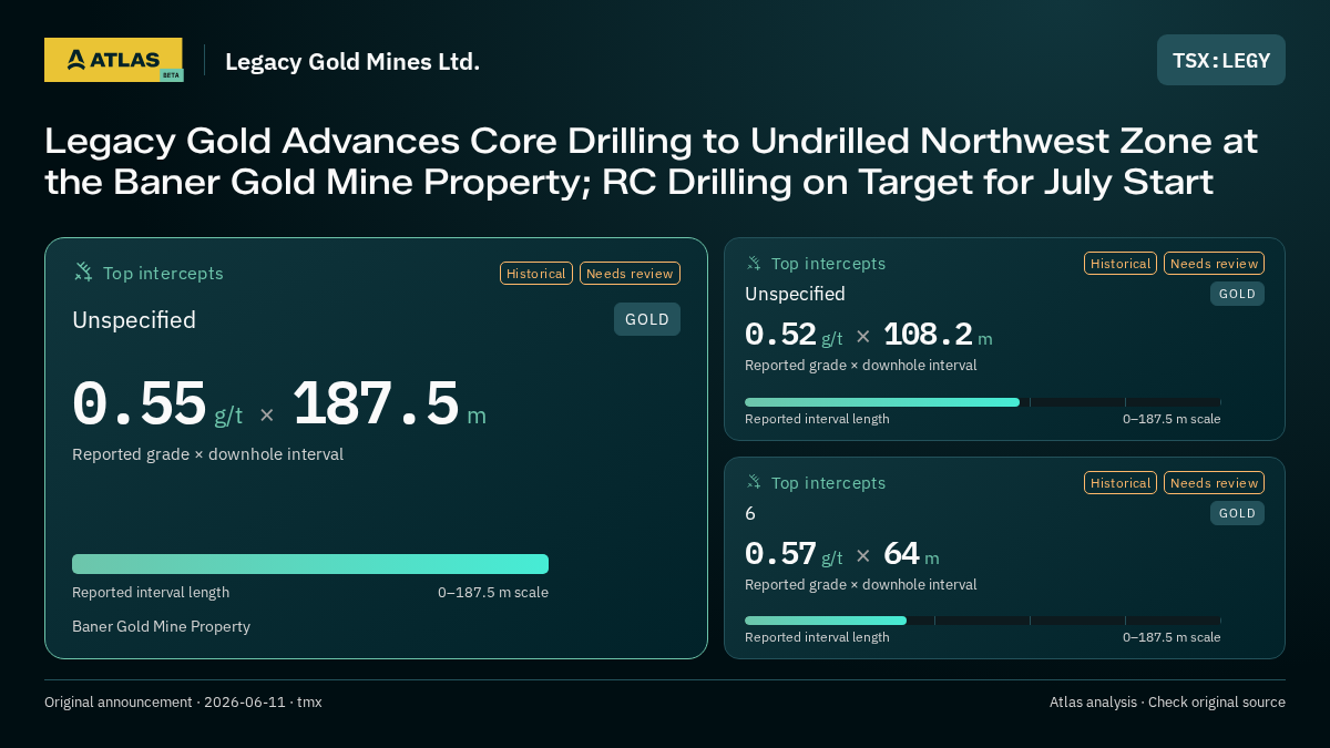
6Baner Gold Mine Property · goldGrade: 0.57Grade Unit: g/tIntercept: 64 mHistorical resultNeeds review: historical_restatementView all detailsHide details
Identity
- Hole ID
- 6
- Project
- Baner Gold Mine Property
- Commodity
- gold
- Region
- usa_id
- Reported Region
- Idaho County, Idaho
- Ticker
- LEGY
Geometry
- Grade
- 0.57
- Grade Unit
- g/t
- Intercept
- 64 m
Classification
- Sample Type
- drill
Review
- Needs Review
- Yes
- Review Reason
- historical_restatement
- Interp. Status
- scored
- Historical
- Yes
- Historical Source Date
- 2025-01-01T00:00:00.000Z
Dates
- Event date
- 2026-06-11T00:00:00.000Z
Reasoning: Historical step-out hole from 2025 reporting a wide, low-grade intersection.
Positive factors
- continuous intersection
Evidence · text
“step-out hole #6 drilled in 2025 that returned a continuous intersection of 0.57 g/t Au over 64.0m (210ft)”
unspecifiedBaner Gold Mine Property · goldGrade: 0.55Grade Unit: g/tIntercept: 187.5 mHistorical resultNeeds review: ungroundedView all detailsHide details
Identity
- Hole ID
- unspecified
- Project
- Baner Gold Mine Property
- Commodity
- gold
- Region
- usa_id
- Reported Region
- Idaho County, Idaho
- Ticker
- LEGY
Geometry
- Grade
- 0.55
- Grade Unit
- g/t
- Intercept
- 187.5 m
Classification
- Sample Type
- drill
Review
- Needs Review
- Yes
- Review Reason
- ungrounded
- Interp. Status
- scored
- Historical
- Yes
- Historical Source Date
- 2025-01-01T00:00:00.000Z
Dates
- Event date
- 2026-06-11T00:00:00.000Z
Reasoning: Historical 2025 intercept in the Main Zone showing significant width at low grade.
Positive factors
- very wide zone
Evidence · text
“0.55 g/t Au over 187.5m (615ft) in the middle”
unspecifiedBaner Gold Mine Property · goldGrade: 0.52Grade Unit: g/tIntercept: 108.2 mHistorical resultNeeds review: ungroundedView all detailsHide details
Identity
- Hole ID
- unspecified
- Project
- Baner Gold Mine Property
- Commodity
- gold
- Region
- usa_id
- Reported Region
- Idaho County, Idaho
- Ticker
- LEGY
Geometry
- Grade
- 0.52
- Grade Unit
- g/t
- Intercept
- 108.2 m
Classification
- Sample Type
- drill
Review
- Needs Review
- Yes
- Review Reason
- ungrounded
- Interp. Status
- scored
- Historical
- Yes
- Historical Source Date
- 2025-01-01T00:00:00.000Z
Dates
- Event date
- 2026-06-11T00:00:00.000Z
Reasoning: Historical 2025 intercept in the Main Zone showing significant width at low grade.
Positive factors
- wide zone
Evidence · text
“0.52 g/t Au over 108.2m (355ft) in the south”
unspecifiedBaner Gold Mine Property · goldGrade: 0.57Grade Unit: g/tIntercept: 64 mHistorical resultNeeds review: ungroundedView all detailsHide details
Identity
- Hole ID
- unspecified
- Project
- Baner Gold Mine Property
- Commodity
- gold
- Region
- usa_id
- Reported Region
- Idaho County, Idaho
- Ticker
- LEGY
Geometry
- Grade
- 0.57
- Grade Unit
- g/t
- Intercept
- 64 m
Classification
- Sample Type
- drill
Review
- Needs Review
- Yes
- Review Reason
- ungrounded
- Interp. Status
- scored
- Historical
- Yes
- Historical Source Date
- 2025-01-01T00:00:00.000Z
Dates
- Event date
- 2026-06-11T00:00:00.000Z
Reasoning: Historical 2025 intercept in the Main Zone showing significant width at low grade.
Positive factors
- continuous intersection
Evidence · text
“0.57 g/t Au over 64.0m (210ft) in the north”
How Atlas produces this analysis
Minestarters Atlas uses automated extraction to summarize mining announcements, identify reported measurements, and classify supporting evidence. Sentiment reflects the extracted narrative and classification rules; it is an interpretation, not a reported measurement. Evidence quotes and context are provided where available. Missing data, low-confidence results, and review flags indicate limitations. Check the original publisher announcement before relying on an interpretation.